Active Travel Route - Ystrad
Consultation has concluded
About the project
As part of the delivery of the Council’s approved Active Travel Network Map (ATNM), this project is looking at how the improvement of an Active Travel Link in Ystrad Mynach could be developed and delivered for pedestrians and cyclists, in line with Welsh Government policy that encourages walking and cycling as a preferred travel mode for journeys within short distances.
The proposed walking and cycling routes are already included on the DataMapWales Active Travel Network Map and seek to establish an initial active travel network for the area, forming part of a wider 15-year ambition to deliver an extensive active travel network throughout the County.
We are looking at a range of different ways that the roads could be redesigned to make it easier to walk and cycle between the A472/Caerphilly Road roundabout and Twyn Road/Caerphilly Road junction. The study will form part of a wider ambition to improve connectivity between key locations such as Ystrad Fawr Hospital, Ystrad Mynach Park, Coleg y Cymoedd, the Centre for Sporting Excellence, Trinity Fields School and Ystrad Mynach Train Station, the Town Centre and Industrial area near Duffryn Park. This phased delivery will form part of CCBC’s overall network to provide Active Travel improvements between Ystrad Mynach, Llanbradach, Caerphilly and Bedwas.
These improvements consider changes that would make travel easier for pedestrians and cyclists such as new crossing facilities, improved dropped kerbs and tactile paving, continuous crossings across side roads etc.
It is important that we capture all the pros and cons of the design options and better understand the needs and aspirations of the local community to improve their quality of life. Ultimately, demands for road space are complex and the process of developing active travel links is an evolving process. The route and connections developed at a later stage will be subject to the appraisal process agreed by the Welsh Government.
Our work is progressing towards a detailed design stage, although no firm decisions have been made on the choice of options at this stage. We are keen to hear about which aspects you like, and you may have concerns about or any better options you wish to propose.
We will use your feedback to develop our designs further and there will be other opportunities for you to comment at a later date.
Please note that when we use the term ‘pedestrian’ or ‘walk’ we are referring not only to those who travel by foot but also users of wheelchairs and other mobility aids.
What is Active Travel
Active travel means displacing car journeys with walking, wheelchair use and cycling for practical, everyday journeys such as shopping, commuting, and accessing services like health and education. Active travel can help reduce carbon emissions and pollution by reducing car use and can also help financially by reducing car dependency for shorter journeys.
All Councils in Wales have a legislative duty to create maps showing their existing and proposed active travel routes. Routes only count as active travel routes if they meet certain minimum standards for safety, directness, and other criteria to ensure that high quality is aspired to and maintained.
Study Area
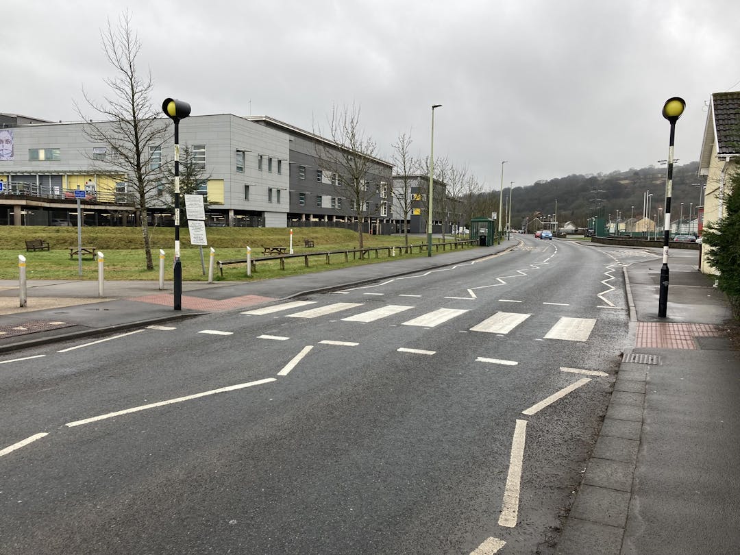
This project looks at the section between the A472/Caerphilly Road roundabout and Twyn Road/Caerphilly Road junction in Ystrad Mynach. As the study emerges, wider links between Ystrad Mynach and settlements such as Llanbradach, Caerphilly and Bedwas will be explored.
The study area reference number on DataMapWales is made up of Routes INMC320, INMC31 and INMC319. The routes tie into several other future routes identified on the Council’s approved active travel layer including INMC328-SC, INMC327, INMC21 and INMC330. Further information is available on DataMapWales.
Option Appraisal
The information below provides a summary of the initial option appraisal undertaken along the study area.
The details are emerging and subject to further detailed appraisal:
- Three crossing facilities on the A472 roundabout (eastbound toward Maesycwmmer, southbound along Caerphilly Road and westbound toward Ystrad Mynach Railway Station) – (Crossing Improvement type/arrangement subject to further review)
- A continuous shared-use path (minimum width of 3.0m) along Caerphilly Road
- Upgrade the existing Zebra crossing along Caerphilly Road to a Parallel crossing
- A pedestrian crossing to access Ynys Glyd Street
- Upgrade the existing crossing at Caerphilly Road/Twyn Road Junction to a Toucan crossing
- Provide a new pedestrian signal-controlled crossing at Caerphilly Road/Twyn Road Junction
The findings of the appraisal will help inform the future design of this route. Further detailed work will be undertaken by AtkinsRéalis to explore active travel improvements in the study area and wider connections in Ystrad Mynach following the completion of this engagement.
Ways to give your views
To comment on the proposals, please complete the online survey. You may also print a copy of the survey for completion.
A copy of the plans and survey are available at Ystrad Mynach Library (High Street, Ystrad Mynach, CF82 7BB) and any completed paper surveys may be returned to your library or in the post to: Caerphilly County Borough Council, Infrastructure Division (Engineering Admin), Ty Penallta, Tredomen Park, Ystrad Mynach, Hengoed. CF82 7PG.
Expected outcomes
Feedback will be considered as part of the design process to develop the detailed designs that will be consulted upon separately.
The outcomes of the consultation will be available within two weeks of the last date of the consultation.
Who's Listening
-
Phone 02920 358 060 Email callan.burchell@atkinsrealis.com
